Networks and Distributed Systems
Research group of Prof. Peter Bernard Ladkin, Ph.D.
Flying An ILS or Localiser Approach - An Example
Peter B. Ladkin
Article RVS-J-97-07Abstract: In order to understand how an aircraft flying under instrument flight rules approaches an airport for landing, one must understand standard instrument approach procedures and documentation. I introduce the procedures and charts used when flying an ILS or localiser instrument approach to an airport, as examples of a precision and non-precision approach respectively. I follow the ILS and localiser-only approaches to Won Pat International Airport in Agana, Guam. There are other traditional non-precision approach types on which I do not comment, such as VOR, VOR/DME, NDB and RNAV. There are also approach types using new-generation avionics technology which are in development but which I don't discuss: Microwave Landing System (MLS) and GPS approaches in particular.
Contents
- Introduction
- Instrument Approach Procedures
- The ILS and Localiser-only Approaches to Runway 6L at Agana
- Running Through a Localiser-Only Approach
- Redundancy in Fix Identification and Course Indication
- Comparison with Other Localiser Approaches
- Footnotes
- References
Introduction
Back to ContentsAn instrument approach is, according to the FAA's Pilot/Controller Glossary
A series of predetermined maneuvers for the orderly transfer of an aircraft under instrument flight conditions from the beginning of the initial approach to a landing or to a point from which a landing may be made visually. It is prescribed and approved for a specific airport by competent authority.
[...]1. U.S. civil standard instrument approach procedures are approved by the FAA as prescribed under [Federal Aviation Regulations] Part 97 and are available for public use.
[...]
(PCG, Instrument Approach Procedure),
ICAO's definition is a little different:
A series of predetermined manoeuvres by reference to flight instruments with specified protection from obstacles from the initial approach fix, or where applicable, from the beginning of a defined arrival route to a point from which a landing can be completed and thereafter, if a landing is not completed, to a position at which holding or en route obstacle clearance criteria apply.
(PCG, Instrument Approach Procedure (ICAO))
In order to acquaint the reader with instrument approach procedures,
I follow and comment on the ILS and localiser-only approaches to
Runway 6 Left at Won Pat International Airport at Agana, Guam.
The ILS is a typical example of a precision approach. Most precision
approaches in the world as of this writing are ILS approaches, and
they're all very, very similar. In contrast, there are many forms
of non-precision approach. It's not possible in this space to consider
all types, so to give a flavor of what all of them involve, namely
identifying
fixes and step-down altitudes; Minimum Descent Altitudes; timing from
Final Approach Fix (FAF) to Missed Approach Point (MAP),
I consider the localiser-only
non-precision version of the ILS Rwy 6L approach to Agana, many
of whose details are identical to that of the ILS.
Instrument Approach Procedures
Back to Contents
How does an approach procedure fit in to the flight of an aircraft
under instrument flight rules?
Normally, Air Traffic Control selects (in consultation
with the pilot) an Approach Procedure for the pilots to
follow to bring the aircraft in from its descent towards the airport
in to the airport and landing itself, in such a way as to avoid all
obstacles that might be in the way on the ground.
At U.S. airports, these standard instrument approach procedures
are designed by the U.S. Federal Aviation Administration to conform to
rigorous standards of obstacle clearance, and have rigorous decision
points for the pilot to decide and `go-around' procedures for himher
to follow if the weather doesn't permit a landing within the
visibility limits of the procedure, or if heshe is in any way
uncomfortable with the progress of the approach.
The Regulatory Background
Back to Contents
These standards are published in a
publically available U.S. Government document
(TERPS).
A standard instrument approach procedure (SIAP) is also
called a Standard Terminal Arrival (STAR) and
is part of the U.S. Federal
Aviation Regulations, Part 97 Paragraph 20.
That is, it is U.S. administrative law.
A chart, known as an
approach plate, which describes a specific terminal
arrival procedure, is printed on one sheet of approximately A5 paper
(about 5"x8" U.S.). It gives a plan view, with the required
track shown, as well as a side view, to show specific altitude
requirements at certain points in the plan.
Approach plates are published by the U.S. government, e.g. for
California
(IAP-CA),
as well as by a few commercial companies such as the
Jeppesen-Sanderson Company,
whose founder, Elrey Jeppesen,
invented the approach plate
(Jepp-Jepp)
(Econ-Jepp).
Radio Procedures and Other Requirements
Back to Contents
An aircraft approaching Agana is normally in radio contact with `Honolulu Center' (Honolulu ARTCC) on HF radio (which is over-the-horizon) and is `handed off' (relevant traffic control information concerning the flight is transmitted between controllers and the aircraft instructed to contact the new controller, who assumes traffic-control responsibility for the flight) to Guam Center about 250nm out, and Guam Center issues the approach clearance, according to Jean-Claude Rudaz, a professional pilot familiar with the route Seoul-Guam (Rud). The aircraft nearing Agana will be handed off to `Guam Approach', the Agana Center Radar Approach Control (Cerap), located at Andersen Air Force Base, about 10nm (nautical miles, 11.5 statute miles) away from the civil airport at Agana. The approach clearance consists of verbal instruction from Guam Center by radio that the aircraft is `Cleared for the XXX Approach', where XXX is one of the approved and published approaches. `Cleared for the ... approach' means that Air Traffic Control (ATC), whose responsibility it is under Instrument Flight Rules to ensure separation of that aircraft from other controlled traffic, authorises that aircraft to perform the XXX approach to the airport:
APPROACH CLEARANCE - Authorization by ATC for a pilot to conduct an instrument approach. The type of instrument approach for which a clearance and other pertinent information is provided in the approach clearance when required [sic].ATC thus undertakes that the airspace required for the approach is kept clear of other controlled traffic for that approaching aircraft for the duration of the approach. Before the aircraft is cleared for the ... approach, the Center controller will have verified whether the aircraft has the ATIS information, recorded information broadcast by radio on the conditions at the airport, in the U.S. updated every hour at 15 minutes to the hour. The ATIS information includes:CLEARED (Type of) APPROACH - ATC authorization for an aircraft to execute a specific instrument approach procedure to an airport; e.g., "Cleared ILS Runway Three Six Approach."
CLEARED APPROACH - ATC authorisation for an aircraft to execute and standard or special instrument approach procedures for that airport. Normally, an aircraft will be cleared for a specific instrument approach.
(PCG)
...b. ATIS information includes the time of the latest weather sequence [recording], ceiling [cloud cover - the amount and altitude of cloud bases], visibility [on the ground], temperature, dew point [the temperature at which the air is saturated with water vapor, therefore at which fog may begin to form], wind direction (magnetic) and velocity, altimeter [setting], other pertinent remarks, instrument approach and runway in use....
EXAMPLE:
DULLES INTERNATIONAL INFORMATION SIERRA, 1300 ZULU WEATHER. MEASURED CEILING THREE THOUSAND OVERCAST. VISIBILITY THREE, SMOKE, TEMPERATURE SIX EIGHT. WIND THREE FIVE ZERO AT EIGHT. ALTIMETER TWO NINER NINER TWO. ILS RUNWAY ONE RIGHT APPROACH IN USE. LANDING RUNWAY ONE RIGHT AND LEFT. DEPARTURE RUNWAY THREE ZERO. ARMEL VORTAC OUT OF SERVICE. ADVISE YOU HAVE SIERRA.
["1300 ZULU" designates 1300 UTC; "SIERRA" is the ICAO phonetic alphabet rendering of the letter `S'. The previous hour's information would have been designated `ROMEO' (`R') and the succeding hour's `TANGO' (`T').]c. Pilots should listen to ATIS broadcasts whenever ATIS is in operation.
d. Pilots should notify controllers on initial contact that they have received the ATIS broadcast by repeating the alphabetical code word appended to the broadcast.
EXAMPLE:
"INFORMATION SIERRA RECEIVED."e. When the pilot acknowledges that he has received the ATIS broadcast, controllers may omit those items contained in the broadcast if they are current. Rapidly changing conditions will be issued by ATC and the ATIS will contain words as follows:
EXAMPLE:
"LATEST CEILING/VISIBILITY/ALTIMETER/WIND (other conditions) WILL BE ISSUED BY APPROACH CONTROL/TOWER."
.....f. Controllers will issue pertinent information to pilots who do not acknowledge receipt of a broadcast or who acknowledge receipt of a broadcast which is not current.
g. [...]
h. Whle it is a good operating practice for pilots to make use of the ATIS broadcast where it is available, some pilots use the phrase "Have the numbers" in communications with the control tower. Use of this phrase means that the pilot has received wind, runway and altimeter information ONLY and the tower does not have to repeat this information. It does not indicate receipt of the ATIS broadcast and should never be used for this purpose.
(AIM, Section 4-13, Automatic Terminal Information Service).
This information is crucial to landing. The weather reports tell the pilot what to expect (including unusual and potentially dangerous conditions such as windshear), the wind direction tells himher what kinds of corrections to heading and descent rate will be needed on the approach, as well as what kind of technique to use on landing (there are different techniques to use depending on where the wind is coming from). The altimeter setting ensures that the altitude displayed on the altimeters in the aircraft cockpit is very, very close to what the real altitude is (see (Lad97-CFIT) for a more detailed explanation of altimetry).
The approaching aircraft, following the published procedure, will pass the Final Approach Fix (FAF) (1) a specific point on the ground 5 to 7 nautical miles (2) from the airport, often a radio beacon, defined in the approach procedure. The FAF also includes an altitude requirement: the FAF is usually 900ft to just over 2000ft above the landing point (this estimate is based on the glide path angle, below, and a FAF distance of exactly 5nm. Both may vary). The angle made by the path which the aircraft follows to landing, the glide path is usually somewhere between 2.5° and 3.5° degrees, though it may be 5° or more for some special procedures for specially-qualified airplanes at special airports. On an ILS, the glide path is given by a radio beam called the glide slope, which at KGUM beams out at exactly 3° upwards from the side of the touch-down zone (TDZ) on Runway 6L. TERPS standards say the glide slope may be 1.7° to 3.77° (Wally Roberts, quoted in (Phi-NPA)). When the aircraft is at and past the FAF, it is on final approach (when the cabin attendants tell you to buckle up because the aircraft is on `final approach' to Los Angeles, they're often misspeaking - the aircraft is still on descent or is on initial approach. Final approach in a B747 takes less than 3 minutes - reckoning with 5 miles at over 2 miles a minute).
At or before the FAF, the approaching aircraft will be instructed `Birdseed 333, Contact Agana Tower', which means to switch to the radio frequency of the airport tower controller. (Often, the en route controller will add `Goodday' to indicate that that is his last expected contact with the aircraft). The aircraft must acknowledge that instruction: `Contact Tower, Birdseed 333, (Goodbye)' and perform it: change to the new radio frequency and announce its presence and position, e.g. `Agana Tower, Birdseed 333, Final Approach Fix inbound' (if not in radar contact, altitude and time are given also - see below). The tower will acknowledge the call, usually clear the aircraft to land, and advise the latest wind information (in the U.S., all control towers have anemometers): `Birdseed 333, Agana Tower, radar contact, cleared to land, wind zero-eight-zero at one-eight [altimeter two-niner niner-zero] (meaning: the aircraft Birdseed 333 is talking to the Agana Tower controller, who has control authority at this point; Agana Tower has identified Birdseed 333 on radar, and Birdseed 333 is authorised by ATC to continue the approach and land at the airport; the wind is from 080° at 18 knots, steady, [and the altimeter setting is 29.90 in the Kollsman window]). The aircraft will land and then be given runway exit instructions and taxi instructions (usually after another `handoff' to a ground controller on a different radio frequency).
The term `radar contact' means:
RADAR CONTACT-
1. Used by ATC to inform an aircraft that it is identified on the radar display an radar flight following will be provided until radar identification is terminated. Radar service may also be provided within the limits of necessity and capability. When a pilot is informed of "radar contact", he automatically discontinues reporting over compulsory reporting points.
[...]
RADAR CONTACT [ICAO]-The situation which exists when the radar blip or radar position symbol of a particular aircraft is seen and identified on a radar display.
(PCG)
If the aircraft is in radar contact, then reporting the FAF is not required (see definition above). However, many pilots report "Final approach fix inbound" anyway (see example above). If there is no surveillance radar at the airport, or it is out of service (OTS), then the radio procedures become a little stricter, because the FAF is a required reporting point for a non-precision approach procedure, such as the localiser-only procedure, when the aircraft is not in radar contact. An aircraft on approach not in radar contact must report to ATC not only that the FAF is reached but also at what time and at what altitude (see FARs and AIM quotes below).
The handoff from Approach to Tower controller happens usually at or before the FAF. Some busy airports such as San Francisco (KSFO) or Los Angeles International (KLAX) have separate controllers for the Terminal Control Areas between en route high-altitude control (`Center') and the airport tower control (`Tower'). These controllers would be addressed as, say "Bay Approach" or "Bay Departure" depending on whether one is approaching or departing the airport. Such control areas usually extend from the surface to 10,000 feet above the airport altitude, with a radius of 20-50 miles, and are known internationally as Class B Airspace (PCG, Controlled Airspace). Agana has no terminal control area, but it does have an approach control. Aircraft switch from the en route controller to Guam Approach, who controls the aircraft's initial approach, to Agana Tower, which controls the aircraft's final approach.
The requirements for a pilot to report hisher position and state of flight vary depending on whether the aircraft is being followed by radar or not. Without radar surveillance, reporting conditions are more stringent than when in radar contact. The precise regulation is:
FAR 91.185: IFR Radio Communications.
The pilot-in-command of each aircraft operated under IFR in controlled airspace shall have a continuous watch maintained on the appropriate frequency and shall report by radio as soon as possible -
(a). The time and altitude of passing each designated reporting point, or the reporting points specified by ATC, except that while the aircraft is under radar control, only the passing of those reporting points specifically requested by ATC need be reported.
(b).......
(FAR, Paragraph 91.185).
5-32. Position Reports.
.......
d. Position Report Items -
1. Position reports should include the following items:
(a) Identification
(b) Position
(c) Time
(d) Altitude or flight level
[rest not applicable to FAF report]
.......
5-33. Additional Reports.
a.The following reports should be made to ATC or FSS facilities without a specific ATC request:
......
2. When not in radar contact:
(a) When leaving final approach fix inbound on final approach (non-precision approach) .......
(AIM, Sections 5-32 and 5-33).
The ILS and Localiser-only Approaches to Runway 6L at Agana
Back to ContentsThe ILS and localiser-only approaches to Agana's Runway 6L are illustrated on the Jeppesen approach chart for the Agana, Guam airport (Jepp-Guam). The (full) ILS, or instrument landing system approach follows two radio beams. One, the localiser, is broadcast from the opposite end of the landing runway, straight down the runway centerline, and gives the aircraft very sensitive relative course indication as to whether it is positioned left of, right of, or on the (extended) runway-centerline. The `width' of this beam at KGUM is 3.64° (Airnav) The glide slope transmitter is located in the touch-down zone (TDZ) of the runway, normally 750ft to 1,250ft down the hard runway surface (see Section The AIM explanation of ILS, Localiser and Glideslope below). The glide-slope at KGUM broadcasts a beam into the sky at an angle of 3° (Airnav) upwards towards the FAF and well beyond. It functions for vertical control of the descent of the aircraft. The aircraft must `fly the glideslope' vertically and `fly the localiser' course horizontally to a precision landing. These radio beams are so sensitive that autopilots can automatically fly them. At some airports (but not at Guam) with some airplanes and certified crew, the autopilot can actually fly the aircraft down the ILS to a landing (wheels on the ground!) Such autoland capabilities were demonstrated first by the British Aircraft Corporation Trident III aircraft in 1965 (Bil97).
The ILS may be flown either full (localiser and glideslope) or localiser-only. Both are approved approaches; the full ILS is a precision approach and the localiser-only approach a non-precision approach. Both require Distance-Measuring Equipment (DME) signals from the UNZ VOR to be available and indicated in the aircraft cockpit. There is also another non-precision approach, the VOR-DME Rwy 6L approach, which uses only azimuth information from the UNZ VOR and distance information from its DME. The approaches differ in how the profile is flown beyond the Final Approach Fix.
When flying the ILS, if the glideslope should suddenly not be
reliably received, the approach may be continued, but it
reverts to a localiser-only approach; that is, should the
glide slope `go out' during an ILS approach, one immediately starts
following and continues to follow the
procedures specified in the localiser-only ILS approach.
This should be no problem, of course, if
all valid positions on the ILS approach are also valid on the
localiser-only approach.
The course information is identical, so the condition would be
equivalent to suggesting
that all legitimate
vertical positions on the ILS are legitimate vertical positions on the
localiser-only approach (but not vice-versa), so a valid
ILS approach profile would also be a valid localiser-only profile.
Let's now look at the approach profile
diagram (below) to see that this is in fact almost the case,
and we shall calculate the differences to show that they do not matter.
Profile
Back to Contents
Let's now consider the profile down which an approaching aircraft must descend into the airport. The following plan is similar to that which would appear on an approach plate:
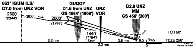
Just to be clear, I must say that This profile is not to be used for navigation. The profile shows that an approaching aircraft, having `captured' (that is, receiving and able to commence flying along the course indicated by) the localiser IGUM, and flying the localiser course of 063°, passes a point 7 nautical miles on the DME from UNZ (`D7.0 from UNZ VOR ' on the left, denoted by the vertical dashed line) at or above 2600ft altitude. (The altitudes in parentheses are the altitudes above the touchdown zone elevation, TDZE, on the runway. Since TDZE is 256ft above mean sea level, MSL, the parenthetical altitudes should all be 256ft less than the MSL altitudes.) After this point, the aircraft may descend to 2000ft altitude up to the point named `GUQQY', which is on the localiser centerline at precisely 1.6 nautical miles DME from UNZ, as written just above the horizontal axis. GUQQY is the Final Approach Fix for the ILS or the localiser-only approach. At GUQQY, the glide slope midline passes through a point slightly lower, at 1864ft altitude. Aircraft making a `full ILS' approach will then fly the midline of the glideslope down towards the runway to an altitude of 456ft on the altimeter, at which point the pilot must either see the runway or its `environment' (various lighting systems), or must `go around' - execute the missed approach procedure; transition to a climb, climb away and either come back for another try or fly to hisher `alternate airport' which was forecast to have better weather.
Aircraft flying the `localiser-only' have no glide slope information. They must instead pass the FAF at 2000ft, then descend to 1440ft altitude until they pass the UNZ VOR, which will be indicated by a reading of almost 0 on the DME (3). At the same time, the VOR indicators on the instrument panel will show `station passage', a `flag' that comes up on the instrument, and the indicator needle will make a sudden large deflection for a couple of seconds. At this point, the aircraft may descend to the Minimum Descent Altitude of 560ft altitude, but may under no circumstances go even one foot below it. The passage beyond the VOR is timed on a stop watch. An aircraft flying at 90 kts may fly for 2 minutes and 56 seconds; at 100 kts, 2 minutes and 38 seconds; at 120kts, 2 minutes and 12 seconds; at 150kts, 1 minute and 53 seconds, before executing the missed approach. (The Missed Approach Point (MAP) is also collocated with the Middle Marker (MM), a radio beacon directing a narrow signal vertically, which is received on the marker beacon panel of the aircraft instruments. Hence the MM serves as well as the stopwatch timing also to indicate the MAP.)
The missed approach procedure is the same for all forms of approach and for any reason for `missing': runway or environment not in sight at MAP, discomfort with the way the approach is progressing, faulty execution of some part of the procedure, an unusual event in the aircraft that requires the crew's attention, etc. Executing a missed approach, the pilot must immediately climb to 2600ft while maintaining the 063° course, then turn right to intercept the 242° radial of UNZ, and fly this radial outbound until 7.0DME. This fix is known as FLAKE and is identical to the IAP marked on the profile and plan views. At FLAKE, the aircraft must hold, that is, fly a specific `racetrack' pattern with the `outbound' leg on the 242° radial and the inbound leg at 062°, beginning to turn outbound again at 7.0DME, all to be flown at 2,600ft altitude. An aircraft on the missed approach and holding at FLAKE is awaiting further ATC clearances to continue.
Finally, let's see if all valid positions on the ILS are also valid positions on the localiser. The ILS glide slope descends 1408ft (= 1864ft - 456ft) from FAF to DH=MM in 4.4nm (= 1.6nm + 2.8nm). That gives a slope of 320ft/Nmile, thus 512ft in 1.6nm. The height of the glide slope centerline over UNZ is therefore 1352ft (= 1864ft - 512ft). This is 88ft below the localiser step-down altitude at UNZ. (This also shows that our profile is a little misleading - it depicts the step-down as being lower than the localiser altitude at UNZ, but it is not, it is higher.) So in fact, if the glide slope beam goes out during an approach, if the aircraft is on glideslop centerline or higher, it is below the step-down altitudes for the localiser at FAF and at UNZ. But notice that although the step-down altitude at FAF is 2000ft, immediately it becomes 1440ft as FAF is passed. This means that the glide slope lies indeed within the localiser-only altitudes for 1.325 of the 1.6 miles to UNZ, and it is only within the last 0.275 Nmiles that it drops this 88ft below. Obstacle clearance on the glide slope at UNZ is 628ft (= 1352ft - 724ft), well over twice that required by the standard. Similarly, for 2.475nm of the 2.8nm from UNZ to MAP, the localiser step-down altitude (the MDA in this case) lies below the glide slope. (Calculation is 1352ft - 560ft MDA = 792ft. Descending 792ft at 320ft/nm takes 2.475nm.) In the remaining 0.325 Nmiles to the MM, the glide slope descends to Decision Height = 456ft.
So the glide slope occasionally descends below the localiser-only
step-downs. We have seen, however, that this happens only for a
very, very short distance before UNZ, and the resulting obstacle
clearance on the glide slope at UNZ is still well over twice what the
standard requires, so this isn't (or shouldn't be) an issue.
Course
Back to Contents
An approximate plan view with symbology similar to that on an approach plate, showing how an approaching aircraft must navigate on the approach to the airport, is:
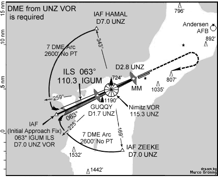
Just to be clear, I must say that This plan is not to be used for navigation. The aircraft will be brought to the Initial Approach Fix (IAF) under ATC control. From this point on, the aircraft will navigate according to the chart. The VOR, identifier UNZ, is shown as the segmented circle in the center of the chart. The chart shows three IAF's, two of them called ZEEKE and HAMAL at respectively 169° and 343° from the VOR, and the third on the localiser centerline at 243° from the VOR (signifying an inbound course of (243° - 180° = 63°); all of them at exactly 7.0 nautical miles on the DME from UNZ. From ZEEKE or HAMAL, the aircraft must fly a circumferential course at a radius of exactly 7.0nm from the DME (a so-called `DME Arc') until beyond the 225° radial of UNZ when flying from ZEEKE, respectively the 259° radial when flying from HAMAL, at which point the aircraft may start its inbound turn towards the localiser course of 063°. (The symbol `NoPT' on the DME arcs means that a `procedure turn' is not allowed. I shall not define the term `procedure turn', since it is not relevant to understanding this approach procedure.) This is called `intercepting the localiser'. Simple geometry shows that the aircraft has to turn through 90° from its DME arc to the localiser inbound course, and this takes some time. At a standard-rate turn, which aircraft are supposed to execute under instrument flight rules and for which the chart is designed, it will take precisely 30 seconds (a standard rate is 2 minutes for 360°) during which the aircraft approaching at 120kts will travel 1nm, supposing there is no wind.
Once the localiser has been intercepted, the aircraft will fly this inbound course, and the profile show previously, until (hopefully) landing. The localiser inbound course, with a symbolic representation of its width, is shown as a bicolor long arrowhead. Various obstacles and their altitudes are indicated: hills and natural features as open triangles and mad-made obstructions as black triangles. There are two man-made obstructions to be extra-careful of: one at 1190ft just south of GUQQY, and one at 724ft just near UNZ (actually, this is the altitude of the VOR building itself - see again (3)). The missed-approach course is indicated approximately as a dashed arrow bending around upon itself beyond the airport runways.
All relevant information for completing this approach is contained
on the single-page Approach Plate, in a standard format with
standard symbology (which may differ according to who publishes the
approach plate, but is more-or-less the same everywhere).
All instrument-rated pilots are accustomed to reading such charts quickly
and accurately, and are required to preview the approach (and other
possible approaches) during their preflight briefing. An example of
an actual chart, which includes more information including the
decision height and MDA, and minimum Runway Visual Range (RVR,
the visibility measured down the runway by special instruments) for
various categories of aircraft (roughly corresponding to slow, medium, fast)
are shown on the Jeppesen approach plate for the ILS Rwy 6L
(Jepp-Guam).
The approach plate includes information on time-to-MAP for
various aircraft speeds; the Decision Height on the ILS; the
Minimum Descent Altitude for the localiser-only approach; various
Runway Visual Range (RVR) restrictions for various categories
(read sizes) of aircraft; the missed approach procedure; various
other essential information such as Minimum Sector Altitudes in the
vicinity of the airport, the airport elevation itself, and the identifiers
of all relevant navaids and of the airport itself.
When an ILS becomes a Localiser-only
Back to Contents
The Localiser-only approach procedure is an approved procedure, defined in FAR 97.20. Normally, different approach procedures are presented on different plates, but the ILS and localiser-only 6L approach are closely related. If a required navaid becomes unreliable during the course of an approach, usually the aircraft must execute a missed approach and seek an alternative. For the ILS/localiser-only, however, if the glide slope is not reliably received, then the ILS reverts to a localiser-only approach - one must not execute a missed approach and come round again. Since DME is required for the localiser-only, it is thus required for the entire ILS procedure in case the glide slope becomes unreliable during the course of the procedure. Also, since the ILS and localiser-only are procedurally related like this, they should be, and are, presented on the same approach plate for the ILS Rwy 6L approach, so that the pilot does not have to hunt for a new piece of paper in the middle of a procedure on which heshe should be concentrating.
To summarise the discussion above, flying the localiser-only approach is a little different in altitude procedures from the ILS. When following the ILS, the pilot will follow the sensitive glideslope down to a decision point at a Decision Height 200ft above TDZE (Touch Down Zone Elevation, at Agana 256ft), reached at a point a half-nautical-mile away from the approach end of the runway. In contrast, the localiser-only approach is defined by `step-down' fixes, at which the aircraft will descend to a new, lower altitude. The localiser azimuth is 063° magnetic to the runway. An approaching aircraft will be flying a course of 063° magnetic, checking the course, with any wind corrections, against the directional gyroscope (that serves the function of a magnetic compass, but doesn't wobble about like a compass in turbulence, or show other compass errors) and against the signal from the localiser, indicated in the cockpit by a needle-line white pendulum called a Course Deviation Indicator, CDI, on a round black background. The CDI hangs straight down if you're on course, hangs left if you're right of course and right if you're left of course. Pilots `follow the needle' to stay on course. It's very intuitive and very effective. See (Lad97-Nav) for a more detailed explanation, with figures, of how a CDI works.
On the ILS, the vertical CDI will be complemented by a similar
horizontal indicator, which indicates deviation (up or down) from
a glide slope centerline. Flying the ILS, the pilot tries to
keep both needles `centered'.
Supposing the glide slope becomes unusable. Then the pilot
on a localiser-only approach is required to use hisher
Distance Measuring Equipment receiver to obtain the distance from
the Nimitz VOR, identifier UNZ.
At 1.6DME, the aircraft is at GUQY, the FAF, and may start the descent
down to 1440ft altitude. At close-to-zero DME (actually, minimum DME
as we noted, 0.11 or so),
the aircraft is overflying UNZ and may start the descent from 1440ft to
560ft altitude.
And at 2.8DME (beyond the VOR now, but the DME doesn't indicate any
difference) lies the MAP. So on the localiser-only approach
it is necessary to identify the
fixes IAF, FAF, UNZ and MAP, and these are all identified by DME
distances. (FAF, UNZ and MAP are also redundantly identified by other
devices, see below.)
Running Through a Localiser-Only Approach
Back to Contents
So it's all pretty straightforward, as it's designed to be.
You set the altimeter calibration
(`Kollsman window') to the setting announced on the ATIS;
tune one nav radio to the
localiser frequency, 110.3, identifier IGUM; another nav and the
DME to UNZ at 115.3; put the marker-beacon display on sound
(if you like it, or leave it as flashing lights if not). Since one Nav
radio
is tuned to IGUM, marker beacon (OM and MM) passage will automatically
be displayed. Then, ATC may direct
you through a sequence of turns to `intercept' the localiser at up to
10 miles out (`Radar vectors to intercept the localiser'),
or may clear you for the approach from HAMAL or ZEEKE.
You reduce speed to approach speed, let's say 120kts, either
now or as the localiser is being intercepted, and descend as
ATC has cleared you. When the localiser is `intercepted', descend to 2000ft
maintaining constant heading (`fly straight'), watch the localiser CDI
needle for any deviation and correct back to course.
`Fly the needle' on the localiser until 1.6 DME/OM indication,
maintaining an altitude of at or above 2000ft on the altimeter. At
1.6DME/OM indication, keep tracking the localiser, announce to ATC you're
at the FAF (ensure they then give you clearance to land), and descend
to (at or above) 1,440ft on the altimeter. At UNZ (minimum DME,
also VOR-passage indication), descend to 560ft altitude and look for
the runway in front of you. If you don't see the runway or its immediate
environment (indicated by various configurations of colored bright lights)
at time 2min12sec (at 120kts)/MM passage/DME 2.8, `go around'
(perform the missed-approach procedure).
Redundancy in Fix Identification and Course
Indication
Back to Contents
Notice how many redundant indications there are for all of the essential navigation for this approach. The compass is backed up by a directional gyro (in fact, at least two of them, on independent systems, on most large civil transports). There are also at least two altimeters, also on independent systems, two ILS indicators, two VOR indicators. However, one nav radio should be tuned to frequency of the localiser IGUM, and the other tuned to the VOR/DME. The VOR indicators should be set to an azimuth of 062°, because this is in fact the reciprocal of the radial on which FLAKE is located. There is in fact a difference of 1° between the localiser inbound course and the UNZ inbound course here. They are not directly aligned, but the difference is insignificant at these distances.
One must set the altimeter properly, and set (and verify against the Morse code identifier signal) the nav radios. All this is done before the approach is started. If either of the radios starts to fail to receive a signal, this is immediately indicated on the nav instruments and the pilot is required to go around - or if the failed equipment is the glide slope and the aircraft is on the ILS, heshe must revert to the localiser-only procedure.
On the approach, after the localiser is intercepted,
the inbound heading as shown on the DG and compass should be
approximately inbound-course heading, with expected wind correction.
The pilot will have estimated wind-correction
from the reported on-airport winds beforehand, but the wind at a
slightly higher altitude, especially as it's flowing around hills,
might not be the same as that recorded on the ground.
Nonetheless, it's an indication.
The localiser CDI needle should more-or-less agree with the
VOR needle. VOR indications should be more-or-less identical to localiser
needles, since the inbound localiser course lies along the
VOR 242° radial (between FAF and VOR) and
between the VOR 063° and 064° radials between VOR and airport.
Both altimeters should read the same (to ensure they have
been correctly set). FAF passage is indicated by both the
Outer Marker beacon (OM, a vertically-projecting beacon similar
to the Middle Marker) and DME;
the next `step-down' to 560ft starts at the VOR, indicated by
close-to-0 DME and by the
VOR indicators signalling `station passage' (there is a special flag
that appears, and usually the VOR indicator needles `go wild' for
about a second).
Finally the MAP is indicated triple-redundantly
by time/DME 2.8/MM passage, which
all indicate it's time
to go around if you haven't seen the runway.
So all one has to do is maintain constant course, as indicated by
compass/DG/VOR/localiser, make three descents (to 2,000ft before the
FAF, then to 1,440 until the VOR, then to 560' until the MAP).
Comparison with Other Localiser Approaches
Back to Contents
All FAA-licensed instrument-rated pilots are able to fly such an approach as the localiser-only ILS 6L at Agana. This non-precision approach appears to be, if anything, somewhat easier from the procedural viewpoint than many (if not most) of the non-precision approaches that, say, I have flown in my Piper Archer. Given what's on the approach plate, I would have no hesitation in flying such an approach, and neither would most of the other pilots I know. One should, however, beware of judging an approach simply by what lies on the approach plate. See Section Potential Difficulties, below.
Not all localiser-type approaches resemble that at Agana.
Other localiser-type approaches may have lower
obstacle clearances, for example, and a bend in them.
KCCR (Concord, California) has a similar localiser-type approach. But the
localiser beam is at 10° off the runway heading, the VOR is
slightly off to one side of the FAF (which is an NDB), there is no
navaid between FAF and MAP, and the approach does not
require DME, (and in fact my airplane had none, so MAP is on timing only
in this case).
There is a 626ft obstacle just to the left of course after the
FAF - and the step-down is from 1,330ft at FAF to 440ft MDA!
Another localiser approach with an OM and MM, and a VOR betweeen
FAF and MAP is at KSCK (Stockton, CA) - but the VOR is again off
to one side. KCCR and KSCK were both within a 50 miles radius of
my home in Berkeley, CA, and were both served by scheduled airline
service (KCCR I believe no more, since the buyout of the carrier and
some `rationalisation' of the buyer-out) and I have flown both
many times. When the VOR does not lie on the localiser course,
then there is no redundant inbound course indication - the localiser
CDI says it all, and VOR will enable only fixes to be established.
Potential Difficulties
Back to Contents
Factors not indicated on the approach design or the approach plate, of course, are peculiar weather conditions, or the reliability of the radio signals.
Local weather conditions can be updrafts, downdrafts or sudden crosswinds at particular places on the approach, a tendency for certain terrain features to be in cloud, and so on. It is crucial for an instrument approach that the pilot concentrates on what hisher instruments are saying, and makes correction for deviations due to air movement, whether steady or sudden.
An example of odd signal attenuation -
the localiser at KOAK Rwy 27R at Oakland,
CA, has or had a notorious `bend' in it, caused, it was surmised,
by some reflective attenuation of the signal off some large
buildings on the ground. Although this bend didn't cause any
real trouble, it could unnerve inexperienced instrument pilots,
who thought they had `nailed' the needle, flying it perfectly,
only to discover it starting to drift off right closer in.
No big deal, of course - at any point, if you don't like your approach,
you can break it off and `go around'. There's no constraint on
breaking off an approach any time you like. That's the ultimate
safety measure.
The AIM explanation of ILS, Localiser and Glideslope
Back to Contents
I have explained how one flies an ILS and a localiser-only approach. However, this explanation would not be complete without specific definitions of all of the technical terms used. To this end, little rivals quoting significant parts of the AIM. So here it is.
1-10 Instrument Landing System (ILS)(AIM, Section 1-10, Instrument Landing System (ILS))a. General
1. The ILS is designed to provide an approach path for exact alignment and descent of an aircraft on final approach to a runway.
2. The ground equipment consists of two highly directional transmitting systems and, along the approach, three (or fewer) marker beacons. The directional transmitters are know as the localizer and glide slope transmitters.
3. The system may be divided functionally into three parts:
- (a) Guidance information - localizer, glide slope
- (b) Range information - marker beacon, DME
- (c) Visual information - approach lights, touchdown and centerline lights, runway lights
4. Compass locators [low-power NDBs] located at the Outer Marker (OM) or Middle Marker (MM) may be substituted for marker beacons. DME, when specified in the procedure, may be substituted for the OM.
5. [....]
b. Localiser
1. The localizer transmitter operates on one of 40 ILS channels within the frequency range of 108.10 to 111.95 MHz. Signals provide the pilot with course guidance to the runway centerline.
2. The approach course of the localizer is called the front course and is used with other functional parts, e.g., glide slope, marker beacons, etc. The localizer signal is transmitter at the far end of the runway. It is adjusted for a course width of (full scale fly-left to a full scale fly-right) of 700 feet at the runway threshold.
3. [....Back-course information]
4. Identification is in International Morse Code and consists of a three-letter identifier preceded by the letter I (..) transmitted on the lozalizer frequency.
EXAMPLE:
I-DIA5. The localizer provides course guidance throughout the descent path to the runway threshold from a distance of 18 NM from the antenna between an altitude of 1,000 feet above the highest terrain along the course line and 4,500 feet above the elevation of the antenna sight. Proper off-course indications are provided throughout the following angular areas of the operational service volume:
- (a) To 10 degrees either side of the course along a radius of 18 NM from the antenna, and
- (b) from 10 to 35 degrees either side of the course along a radius of 10 NM [...]
6. Unreliable signals may be received outside these areas.
c. Localiser-type Directional Aid [Describes an installation of a localizer without a glide-slope at an airport]
d. Glide Slope/Glide Path
1. The UHF glide slope transmitter, operating on one of the 40 ILS channels within the frequency range 329.15 MHz, to 335.00MHz radiates its signals in the direction of the localizer front course. The term "glide path" means that portion of the glide slope that interscets the localizer.
[...]
2. The glide slope transmitter is located between 750 feet and 1,250 feet from the approach end of the runway (down the runway) and offset 250 to 650 feet from the runway centerline. It transmits a glide path beam 1.4 degrees wide. The signal provides descent information for navigation down to the lowest authorized decision height (DH) specified in the approved ILS approach procedure. The glidepath may not be suitable for navigation below the lowest authorized DH and any reference to glidepath indications below that height must be supplemented by visual reference to the runway environment. Glidepaths with no published DH are usable to runway threshold.
3. The glode path projection angle is normally adjusted to 3 degrees above horizontal sothat it intersects the MM at about 200 feet and the OM at about 1,400 feet above the runway elevation. The glide slope is normally usable to the distance of 10 NM. However, at some locations, the glide slope has been certified for an extended service volume which exceeds 10 NM.
4. Pilots must be alert when approaching the glidepath intercetpion. False courses and reverse sensing will occur at angles ocnsiderably greater than the published path.
5. Make every effort to remain on the indicated glide path (reference: FAR 91.129(d)(2)). Exercise caution: avoid flying below the glide path to assure obstacle/terrain clearance is maintained.
6. The published glode slope threshold crossing height (TCH) DOES NOT represent the height of the actial glide path on-course indication above the runway threshold. It is used as a reference for planning purposes which represents the height above the runway threshold that an aircraft's glide slope antenna should be, if that aircraft remains on a trajectory formed by the four-mile-to-middle-marker glidepath segment.
7. Pilots must be aware of the vertical height between the aircraft's glide slope antenna and the main gear in the landing configuration and, at the DH, plan to adjust the descent angle accordingly if the published TCH indicates the wheel crossing height over the runway threshold may not be satisfactory. Tests indicate a comfortable wheel crossing height is approximately 20 to 30 feet, depending on the type of aircraft.
e. Distance Measuring Equipment (DME)
1. When installed with the ILS and specificied in the approach procedure, DME may be used:
- (a) In lieu of the OM.
- (b) As a back course (BC) final approach fix (FAF).
- (c) To establish other fixes on the localizer course.
2. In some cases, DME from a separate facility may be used within Terminal Instrument Procedures (TERPS) limitations:
- (a) To provide ARC initial approach segments.
- (b) As a FAF for BC approaches.
- (c) As a substitute for the OM.
f. Marker Beacon
1. ILS marker beacons have a rated power output of 3 watts or less and an antenna array designed to produce an elliptical pattern with dimensions, at 1,000 feet above the antenna, of approximately 2,400 feet in width and 4,200 feet in length. Airborne marker beacon receivers with aa selective sensitivity feature should always be operated in the "low" sensitivity position for proper reception of ILS marker beacons.
2. Ordinarily, there are two marker beacons associated with an ILS, the OM and MM. Locations with a Category II and III ILS also have an Inner Marker (IM). When an aircraft passes over a marker, the pilot will receive the following indications: (See Table 1-10[1]).
Table 1-10[1]
MARKER CODE LIGHT OM --- BLUE MM .-.- AMBER IM .... WHITE BC .. .. WHITE
- (a) The OM normally indicates a position at which an aircraft at the appropriate altitude on the localizer course will intercept the ILS glide path.
- (b) The MM indicates a position approximately 3,500 feet from the landing threshold. This is also the position where an aircraft on the glide path will be at an altitude of approximately 200 feet above the elevation of the touchdown zone.
- (c) The inner marker (IM) wll indicate a point at which an aircraft is at a designated decision height (DH) n the glide path between the MM and landing threshold.
3. [Back course markers...]
g. Compass Locator
1. Compass locator transmitters are often situated at the MM and OM sites. The transmitters have a power of less than 25 watts, a range of at least 15 miles and operate between 190 and 535 kHz. At some locations, higher powered radio beacons, up to 40 watts, are used as OM compass locators. These generally carry Transcribed Weather Broadcast (TWEB) information.
2. Compass locators transmit two letter identification groups. The outer locator transmits the first two letters of the localizer identification group, and the middle locator transmits the last two letters of the localizer identification group.
h. ILS Frequency [Tables]
i. ILS Minimums
1. The lowest authorized ILS minimums, with all required ground and airborne systems components operative, are
- (a) Category I - Decision Height (DH) 200 feet and Runway Visual Range (RVR) 2,400 feet (with touchdown zone and centerline lighting, RVR 1800 Category A, B, C; RVR 2000 Category D).
- (b) Category II - DH 100 feet and RVR 1,200 feet.
- (c) Category IIIA - RVR 700 feet
1-10i1c NOTE.-Special authorization and equipment are required for Category II and IIIA.
j. Inperative ILS Components
1. Inoperative localizer: When the localizer fails, an ILS approach is not authorized.
2. Inoperative glide slope: When the glide slope fails, the ILS reverts to a nonprecision localizer approach.
[....]
An ILS is flown using the CDI needle, with the VOR receiver set to the
ILS frequency. The OBS is not used, although most pilots find it appropriate
to set the localizer inbound course in the OBS. The CDI is more
sensitive than with a VOR, with about one dot per degree deviation.
The glideslope DI is an additional horizontal needle, pivoted on
the left, that shows when the glideslope is received. It indicates
similarly to the vertical CDI - a deviation upwards means `below
glideslope, fly up to recapture glideslope', and a deviation downwards
indicates `above glideslope, descend to recapture glideslope'. When
the localiser CDI lies vertically downwards and the glideslope DI
horizontal, the aircraft is exactly on course and on glideslope.
Peter Ladkin
Footnotes
Back to Contents
(1):
Strictly speaking, an FAF is not required for the procedure. For an ILS
without a FAF, a pilot will perform what's know as a procedure turn,
flying over the airport or a specific navaid, outbound along the
course heshe will follow inbound, and then perform a specific manoeuvre
to reverse couse 180° and fly back in along the ILS.
Back
(2):
A nautical mile (also denoted here by Nmile, NM
and nm) is about 7/6 of a normal (Statute) mile. It represents
the distance that 1 minute of arc (1 minute = 1/60 of a degree)
measures on the circumference of the earth at the equator. 1 minute
of latitude is thus always 1nm, whereas 1 minute of longitude varies
in length depending on what latitude one is. At Vancouver, in Canada,
at just above 49° North latitude, a degree longitude is about 39nm,
which is thus about what it is in Paris or Stuttgart.
At San Francisco, at 38° North, a degree longitude represents
48nm, about what it is in Seville or Sicily.
See
(Lad97-Nav)
for more details.
Back
(2):
They will be passing some 716ft above the VOR station,
so the DME will in fact read a minimum 0.11, which is 716ft converted to
nautical miles. Where does the figure of 716ft come from? On the plan,
one can observe a tower height 724' at the location of the VOR. This
is the altitude of the top of the VOR building, formed by a round white
cone. The DME is inside the building. So 716ft is simply 1440ft - 724ft,
the minimum crossing altitude minus the altitude of the top of the hut.
Back
References
Back to Contents
(AIM): U.S. Department of Transportation, Federal Aviation Adminstration, Aeronautical Information Manual (AIM), Author, annual. Back
(Airnav): Paulo Santos, The AirNav Database, http://www.airnav.com. Back
(Bil97): Charles E. Billings, Aviation Automation: The Search for a Human-Centered Approach, New Jersey:Lawrence Erlbaum Associates, 1997. Back
(CNN-05b): CNN, Rescuers search smoldering jet debris in Guam, at http://cnn.com/WORLD/9708/05/guam.later/. Author, August 6, 1997. Back
(Econ-Jepp): Anonymous Elrey Jeppesen, Obituary, The Economist, December 14, 1996. Back
(FAR): U.S. Department of Transportation, Federal Aviation Administration, Federal Aviation Regulations, Author, continuous. Available at http://www.faa.gov/avr/AFS/FARS/far_idx.htm Back
(IAP-CA): U.S. Department of Commerce, National Oceanic and Atmospheric Administration, National Ocean Service, United States Government Flight Information Publication: U.S. Terminal Procedures: Southwest (SW) Vol 2, Author, continuous publication approximately every two months. Back
(Jepp-Guam): Jeppesen-Sanderson Company, Agana, Guam, ILS Rwy 6L approach, at http://www.jeppesen.com/guam.html, Author, August 1997. Back
(Jepp-Jepp): Jeppesen-Sanderson Company, Captain E.B. Jeppesen, Aviation Pioneer and Colorado Businessman, Dies at 89, at http://www.jeppesen.com/prjepp.html, Author, November 1996. Back
(Lad97-CFIT): Peter B. Ladkin, Controlled Flight Into Terrain: What is Being Done, Essay RVS-J-97-07, at http://www.rvs.uni-bielefeld.de -> Publications, August 1997. Back
(Lad97-Nav): Peter B. Ladkin, Traditional Aviation Radio Navigation: An Introduction, Essay RVS-J-97-08, at http://www.rvs.uni-bielefeld.de -> Publications, August 1997. Back
(Lew): Paul Lewis, with David Learmount and Ramon Lopez, Korean Air investigators focus on possible CFIT, Flight International, 13-19 August, 1997, p4. Back
(McK): James T. McKenna, Guam Crash Underscores Navaid, Training Concerns, Aviation Week and Space Technology, August 11, 1997, pp35-36. Back
(PCG): U.S. Department of Transportation, Aeronautical Information Manual: Pilot/Controller Glossary, Author, annual. Back
(Phi-NPA): Edward H. Phillips, Safety of Nonprecision Approaches Examined, Aviation Week and Space Technology, August 18, 1997, pp23-29. Back
(Rud): Jean-Claude Rudaz, personal communication, September 4, 1997. Back
(TERPS): U.S. Department of Transportation, Federal Aviation Administration, United States Standard for Terminal Instrument Procedures (TERPS), 8260.3B, July 1976, U.S. Government Printing Office. Ordering information and on-line order forms are available from http://www.terps.com/gpo, a subpage on Wally Roberts's site Wally's TERPS Page, http://www.terps.com. Back